In 2013 I gave myself a photo assignment. Pick 13 subjects, and take 13 snapshots of each… 13x13x13. At some point during the project I decided it’d be much more interesting to open this assignment to anyone who wants to participate. I’m glad I did. The following series of 13 comes from local photographer Arleen Hodge . These are portraits of 13 Rochesterians she’s met on the streets. Arleen says she is grateful to call these people her “friends.”
“They all have stories and they are truly a great bunch of men who are suffering another facet of the human condition,” Arleen reasons. “When I’m shooting underground for a night, these guys look out for me. There are those who are quick to judge… but these would be the guys to jump in and save your life.”
I can think of no better subject for this merry time of year – and less than a week after we were forced to face the facts; that Rochester stands as the fifth poorest city in the United States. It’s not just a city problem. According to that report by The Rochester Area Community Foundation, 160,000 people living within the nine-county region are living in poverty. These are our neighbors. Our friends. These could easily be portraits of you or me…
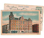
This former department store (Sibley, Lindsay & Curr Company) is truly massive. Rochester’s Sibley Building weighs in at over 1.1 million square feet (23 acres of floorspace) – easily the largest building in Monroe County.
WinnCompanies out of Boston now owns the property and plans to spend up to $200 Million over the next five years to bring it back to life as mixed-use space. Holy smokes, do these guys have their work cut out for them. You may have noticed new windows and awnings along Main Street? Some 2,000 windows have yet to be replaced.
Last week the UofR Urban Explorers Club went on a tour through the maze of hallways and spaces, from the dark sub-basement all the way up to the two massive water tanks on the tower rooftop…
Earlier this year we took a look at some amazing photos of this abandoned swimming pool on the University of Rochester campus. Within days of those photos being posted here, the university had cleaned up the scene. These new photos got lost in my computer which is why you’re just seeing them now. But I thought it was worth revisiting…
This final part serves to tie up some loose ends, and to showcase additional trail options and connections in the region. Here, we will go on an alternative route North to the lake, this time on the east side of the river gorge, and check out the parkway and Route 390 trails, which provide us with additional connections. [View this route in Google Earth using this .KMZ file]
I stopped by Iola on Sunday to check on what’s left, and I snapped these pics. In front of the main building there was once a circle with concrete benches and lamp posts. To be perfectly honest I coveted the abandoned lamp posts and thought of ways I could possibly “reclaim” them, but my conscience always prevented me from doing so. Well, I should have because the picture above shows the careful attention the deconstruction crew is taking to features that could be re-used. That’s the base and the flattened steel post is above it. I think my reclamation would have been better than this treatment. Damn conscience.
The fourth part of the Bike Rochester Series differs quite a bit from the previous ones. We will be venturing on old railroad rights of way (train tracks converted to trails via Rails to Trails Programs). The biggest difference here is that these trails are not paved; they are packed dirt/grass and crushed stone (similar to parts of the unpaved canal trail). So a road bike is not recommended, however a hybrid bike will be more than comfortable and safe. This is the perfect ride to do during the Fall!
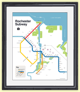
I often get asked if there are tours of the Rochester subway. The short answer is no. The longer answer is while there is no official tour of the “subway,” every October there is usually a tour of the “historic Erie Canal aqueduct.” And it’s coming up this weekend…
In this third piece exhibiting Rochester’s bicycle trails, we will be returning to the Erie Canal Heritage Trail. Click HERE and HERE to see parts one and two, respectively. This time, we will be heading westbound towards Brockport. Although there is not much of a net elevation change between downtown and Brockport, it feels a bit more hilly than the eastbound trail. As we will see, the towns and hamlets we will encounter on this western route have a different character to them than the ones on the eastern trail…
Last week a reader, Michael Krauklis, sent me this picture and asked two perplexing questions. Michael said, “I’ve worked downtown just next to the Broad Street bridge for 11 years now, and the entire time there has been a strange feature in the river just south of the bridge . Upon first glance it appears to be a spring, in the middle of the river, but with further inspection one can see the carcass of an old abandoned structure surrounding it… What was the original purpose of this and where is the water is coming from?”
I have seen these strange concrete triangles in the river myself, and I know there are more than one of them. But I had never noticed the spring water bubbling up! In either case, I had no good answer for Michael. So, I started digging. Here’s what I found out…
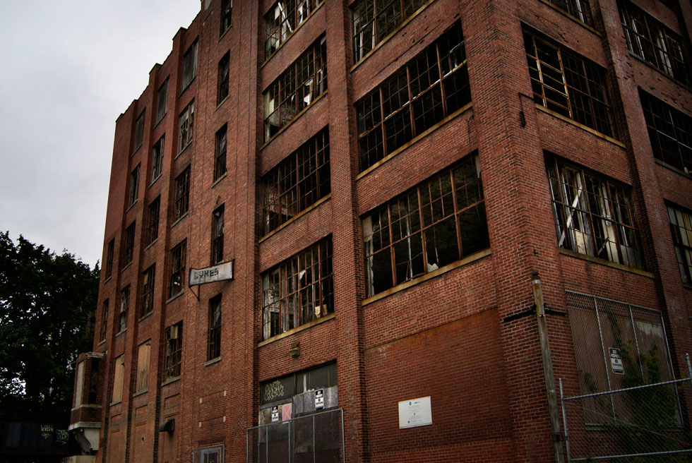
If you’ve ever driven down the eastern end of Lyell Ave., or been to a soccer game at Sahlen’s Stadium, you’ve probably seen an enormous old shell of a building looming in the distance. Many times I had seen it’s old edifice sitting silent and, as I usually do, I wondered what the walls contained, what stories it could tell, and what it once was. That’s why one cool September morning I went to meet with the building and see what it could tell me…
The second part of The Biking in Rochester Series showcases the route from downtown to Lake Ontario, following the Genesee River Trail. It is 20 miles, roundtrip, from downtown to the end of the pier at Lake Ontario Beach Park and back. Actually, I’ll take us a bit further and ride along the lake shore, east to Sea Breeze – adding another 8 miles to the trip.
Although this route is not as consistently scenic as the first one, it has much better rewards, and you get more of a workout. We’ll pass by 3 waterfalls, 3 beaches, 3 lighthouses, and two piers out onto the big lake. The western portion of this route is on the Genesee Riverway trail, a mostly completely dedicated bike path such as the one on the canal. The eastern portion is on King’s highway/Goodman street…
This is the first in a series of photo tours aimed at encouraging people in the Rochester area—regardless of cycling ability—to get out and enjoy the plethora of trails we have. It is written as an introduction, although most people around here are probably already familiar with some of the trails. Disclaimer: I am not a local… and no where near a veteran cyclist!
Before we begin, I want to point out an advantage Rochester has over some of its upstate neighbors of similar size using Google maps… Buffalo, Rochester, Syracuse/Central NY, Albany/Capital District. Granted, these maps are not 100% accurate. Nor are many of the paths paved. Still it helps give us an idea, in part, why Rochester was named the most bike friendly region in upstate New York (just barely making it on to the top 50 bike friendly cities in the USA ).
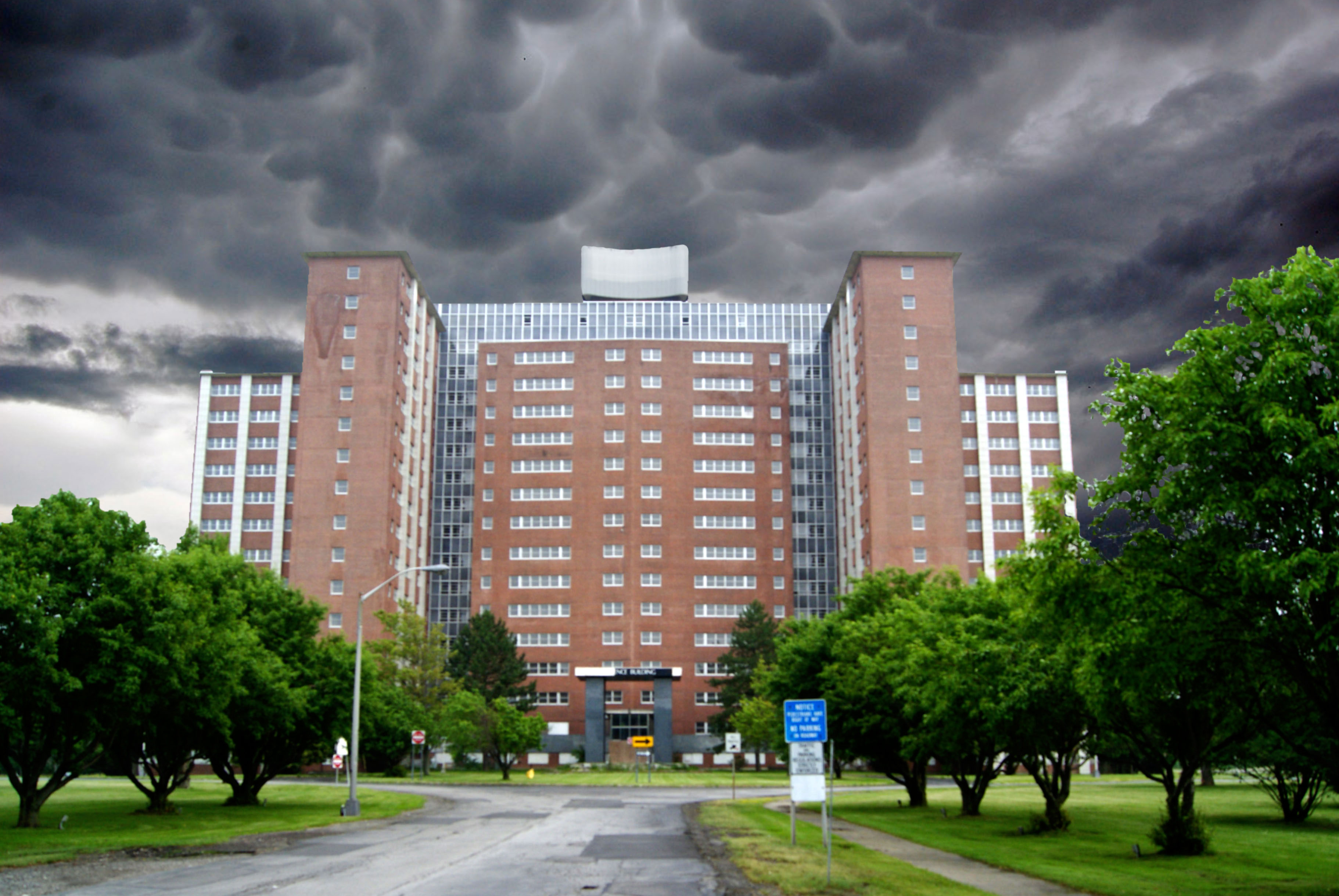
This is probably the most intimidating building in all of Rochester. The 16-story Terrence Building was once heralded as a “tower of hope” for the mentally ill (see this blog post ). Today the vacant structure looms over Elmwood Avenue and the Rochester Psychiatric Center campus like a nightmare. The Elmwood psych center campus was originally constructed as the Rochester State Hospital. This state-run mental hospital took over responsibilities from the Monroe County Insane Asylum in 1891. The Terrence Building was opened in 1959 and housed over 1,000 beds until 1995 when the last patients were moved to newer facilities elsewhere on the campus.
If you’ve ever wondered what’s inside, you’d not be alone. One RocSubway reader (who wishes to remain anonymous) found a way into the secured building. He submitted several photos, along with this written account of his expedition. Be sure to watch the related video at the end of this post to learn more about the Terrence Building…
RocSubway fans, This past Sunday morning (6/2/13), I went with a friend of mine to check out the Iola Campus site . I have lived in Rochester all my life and I have always been intrigued by those buildings (my aunt actually used to live in the apartments across the street). About 6 months ago, I started a little urban exploring group with some friends and coworkers; Iola was one of the first places of interest. With the CityGate project fast approaching, I knew I had to take the risk and visit Iola while I still could. Rather than taking a big group, just two of us went since we were not sure what the security situation would be like. The whole campus was great. A lot of the buildings had pretty easy access points, but there were a couple we could not get in to, due to time constraints (and proximity to the main road!). I hope that you all enjoy the shots! – Sarah Barnes
John Failings Barber settled in the area of Portage, NY during the pioneer days. He struggled with tragedy and hardship and eventually became a prosperous farmer and banker. He built this home—which he called, “Chestnut Place”—on the corner of Short Tract and Oakland roads . Before I continue, please be advised, this house is on posted private property.
Emily Stauring is a photographer from Arkport, NY. She took most of these photos while out for a drive with a friend…
“It’s one of the eeriest, strangest places I’ve ever been.” That’s what Chris Seward said of this little known spot on the University of Rochester campus when he took these photos. The Merle Spurrier Gymnasium opened in 1955 as part of a women’s center and the Susan B. Anthony women’s dormitory. Spurrier housed this 25-yard-long, six lane swimming pool. According to a 2004 Campus Times article , the pool has been closed ever since the women’s gym facilities were moved to the Robert B. Goergen Athletic Center in 1982…
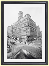
Ryan Green is a student at University of Rochester. Last month, after joining up with the University’s Urban Explorers (UrbEx ) club, he toured Rochester’s Times Square Building, formerly the Genesee Valley Trust Company . You probably know it by the enormous set of wings on top of it. Aside from maybe the Mercury statue, those “wings of progress” are easily the most recognizable element of Rochester’s skyline. And while they have a story all their own, there’s plenty more history to be found on the fourteen floors beneath.
Although the building is not open for public tours, Richard Calabrese Jr., who manages the property, says he likes touring the urban explorer group because of their genuine curiosity. Although, if a fundraising tour is requested, Calabrese says he’d consider that. “I have all kinds of history that I’ve learned over the years.” Ryan Green had such a good time touring the building, he wanted to share these photos, and his experience, with us…
Just when I think I’ve done everything there is to do in Rochester, I discover another little hole in the wall. Literally. Check out these photos of what is unofficially known as “Rico Cave” near Lower Falls…
On Friday officials at the Genesee Brewery unveiled plans they say will “create a destination for beer lovers that anchors development on downtown Rochester’s Northeast side.” Before we get too excited, let’s think.
Firstly, did you know Genesee Brewery is owned by a New York City investment firm called KPS Capital Partners? KPS Capital Partners established North American Breweries, Inc. in 2009 to manage its brewery acquisitions. One of those acquisitions was our beloved Genesee. They will tell you North American Breweries is headquartered in Rochester. But Genesee Brewery is no longer a locally owned company.
North American Breweries says their planned “Genesee Brew House…will celebrate the storied history and experience of the Genesee brand” and that they want to “tell the story of [this] resilient company with a rich history that dates back to 1878.” But to do this they will demolish this building; the centerpiece of Rochester’s historic brewing district, built 1899.
“And the sign said, The words of the prophets are written on the subway walls.” If Simon & Garfunkel are right, these photos could be considered divine. They were taken over the past 2 years by local photographer Lizz Comstock and shared with us today via RocSubway’s Facebook page.
It was abandoned by Rochester Transit Corporation over 55 years ago, but as debris piles up and messages are written on top of other messages, the walls of Rochester’s subway tunnel seem to echo with indelible voices. And these photos are wonderful illustrations of the life that can still be found beneath our streets.
Get Email Updates...
Stay up-to-date on Rochester-related stories, artifacts, and ideas that you won't find in the mainstream news.
Totally free, never spammy, and you can unsubscribe at any time.
After the Erie Canal was rerouted south of downtown Rochester, the Rochester
Industrial & Rapid Transit Railway (the “subway”) was built in
its place as a link between the five different railroads and interurban trolley
lines that served the Rochester area. As the industrial landscape of Rochester
changed, and highways replaced the railroads, the Rochester subway gradually
became a relic of a bygone era. In 1956 the subway was abandoned and much of
its route was converted into Interstate 490 — built to connect Rochester
with the New York State Thruway (I-90). Read more about the history of the Rochester Subway.
RochesterSubway.com exists to help spark
public dialogue around how we can better connect the neighborhoods of Rochester
NY, surrounding communities, and their cultural offerings. Rochester’s
future is written in her past. Let's rediscover it.


![13 Rochesterians [PHOTOS BY: Arlene Hodge]](https://www.rochestersubway.com/images/photos/13-homeless-rochesterians.jpg)
![The Sibley Building, Rochester NY. [PHOTO: RochesterSubway.com]](https://www.rochestersubway.com/images/photos/rochester-sibley-building-01.jpg)
![The abandoned swimming pool at University of Rochester has been cleaned of its desk chairs. [PHOTO: RochesterSubway.com]](https://www.rochestersubway.com/images/photos/university-of-rochester-abandoned-pool2-01.jpg)
![The fifth and final part of Ryan Green's Bike Rochester Series... the El Camino and Route 390 Trails! [PHOTO: Ryan Green]](https://www.rochestersubway.com/images/photos/rg-bike-rochester-el-camino-and-route-390-trails-014.jpg)
![The abandoned Iola Tuberculosis Sanatorium. [PHOTO: Matt Rieck]](https://www.rochestersubway.com/images/photos/iola-tuberculosis-sanatorium-matt-rieck-01.jpg)
![The fourth part of the Bike Rochester Series... let's hit the Genesee Greenway and Lehigh Valley Trails! [PHOTO: Ryan Green]](https://www.rochestersubway.com/images/photos/rgbike-rochester-genesee-valley-greenway-lehigh-valley-trail-LV101.jpg)
![A tour of Rochester's abandoned subway tunnel. [PHOTO: RochesterSubway.com]](https://www.rochestersubway.com/images/photos/abandoned_rochester_subway_05.jpg)
![In this third piece exhibiting Rochester's bicycle trails, we will be returning to the Erie Canal Heritage Trail to visit Brockport, NY. [PHOTO: Ryan Green]](https://www.rochestersubway.com/images/photos/rgbike-rochester-to-brockport-B102.jpg)
![I have seen these concrete triangles in the river before. But I had never noticed the spring water bubbling up. What is this strange water feature? [PHOTO: Michael Krauklis]](https://www.rochestersubway.com/images/photos/genesee-river-triangle-rochester.jpg)
![Turning Point Park boardwalk. [PHOTO: Ryan Green]](https://www.rochestersubway.com/images/photos/rgbike-bike-to-lake-ontario-25-turning-point-park-boardwalk3.jpg)
![Ryan Green takes us on a bike ride from downtown Rochester to Fairport. [PHOTO: Ryan Green]](https://www.rochestersubway.com/images/photos/rgbike-erie-canal-path-return-04.jpg)
![The abandoned Iola Tuberculosis Sanatorium. [PHOTO: Sarah Barnes]](https://www.rochestersubway.com/images/photos/iola-tuberculosis-sanatorium-001.jpg)
![The old Barber House at the corner of Short Tract and Oakland Road in the Town of Portage. [IMAGE: Emily Stauring]](https://www.rochestersubway.com/images/photos/abandoned-barber-house-portage-ny-01.jpg)
![A little known abandoned swimming pool at University of Rochester. [IMAGE: Chris Seward]](https://www.rochestersubway.com/images/photos/university-of-rochester-abandoned-pool-01.jpg)
![A photo of a photo of a man atop the Times Square Building, Rochester, NY. [PHOTO: Ryan Green]](https://www.rochestersubway.com/images/photos/times-square-building-rochester-02.jpg)
![Rico Cave in the Genesee River gorge near Lower Falls. [Flickr PHOTO: bobbybeans]](https://www.rochestersubway.com/images/photos/rochester-rico-cave-bobbybeans-1.jpg)

![The building as it was in 1899. [PHOTO: Rochester Public Library]](https://www.rochestersubway.com/images/photos/genesee-brewery.jpg)
![Rochester subway tunnel. [PHOTO: Lizz Comstock]](https://www.rochestersubway.com/images/photos/lizz-comstock-subway-01.jpg)


