At a cost to the New York taxpayer of just about half that of the Louisiana Purchase fourteen years earlier, “Clinton’s Ditch” faced the ageless and indestructible rancor of the New York State Legislature and the animosity of the press statewide. It is hard to overstate the impact the investment taxpayers made in building the canal had on the development of Rochester and New York State. Now, it is almost impossible to imagine a project like the canal ever being built in today’s political climate and maybe that is not such a good thing. In this edition of Wear to Where we stop by Lock 33 and ask, “What’s the big idea?”…
A recent email from a RocSubway reader asks: “There is a building on Moore Road in Genesee Valley Park that looks like some kind of bird house, maybe a pigeon coop. It’s so close to the edge of the [University of Rochester] property that I wondered if it was theirs, rather than part of the park. Someone is taking care of it as the paint doesn’t appear to be that old. Thought its origin might be interesting. Any ideas?”
I’ve noticed this building before too, and because of those tiny holes in the upper level, I’ve always assumed it was a birdhouse. But I admit, I really am not sure. So I asked JoAnn Beck, Senior Landscape Architect with the City of Rochester…
On May 19, 1911, a 150 foot long break occurred in the wall of the New York State Barge Canal at Bushnell’s Basin. Construction on this section of canal had just been completed eight days earlier.
According to an article in the Monroe County Mail, it was a canal worker, John McCarthy, who at 4pm discovered water pouring through a narrow crack in the canal bank…
RocSubway is excited to share with you some exclusive pictures of an exciting downtown development. 210 South Avenue is currently being transformed into future commercial and residential space in the heart of downtown Rochester. The building currently known as the Merkel Donohue building—and its connected buildings—will be transformed into a mix of commercial & residential space and will go by the name of Woodbury Place…
With all of the recent flooding in our area, RocSubway reader Michael Delaney wrote in and suggested, “a great idea for an article would be about the history of flooding in Rochester and the civil engineering that has gone into solving the issue. Beyond the dams, I’ve heard that there are huge storm sewer tunnels underneath the city. It would be very interesting to know more about it.”
Situated at the intersection of the Genesee River and Erie Canal, Rochester’s geography has blessed—or cursed—us with a long long history of great floods. Before the construction of the Mount Morris Dam (1948-1952) records indicate the City of Rochester had experienced severe flooding about every seven years between 1865 and 1950. Talk about a pesky problem.
Digging into all of the engineering marvels that have spared modern Rochesterians from most of these high waters could easily span many pages. And I promise to dedicate future posts on the subject. But for now, I want to show just how bad this problem was by highlighting just one flooding disaster that occurred in late March, 1913…
This final part serves to tie up some loose ends, and to showcase additional trail options and connections in the region. Here, we will go on an alternative route North to the lake, this time on the east side of the river gorge, and check out the parkway and Route 390 trails, which provide us with additional connections. [View this route in Google Earth using this .KMZ file]
If you’re like me, and you enjoy exploring local places most people overlook, here’s a neat project you might want to support. Benjamin Woelk (30, Rochester) and Jason Darnieder (Flower City Media) are working on a documentary travel series that focuses on exploring upstate and western N.Y. He’s calling the project “Slow Road” – a documentary series dedicated to sustaining community, preserving the past, and exploring America’s roads less traveled…
The fourth part of the Bike Rochester Series differs quite a bit from the previous ones. We will be venturing on old railroad rights of way (train tracks converted to trails via Rails to Trails Programs). The biggest difference here is that these trails are not paved; they are packed dirt/grass and crushed stone (similar to parts of the unpaved canal trail). So a road bike is not recommended, however a hybrid bike will be more than comfortable and safe. This is the perfect ride to do during the Fall!
In this third piece exhibiting Rochester’s bicycle trails, we will be returning to the Erie Canal Heritage Trail. Click HERE and HERE to see parts one and two, respectively. This time, we will be heading westbound towards Brockport. Although there is not much of a net elevation change between downtown and Brockport, it feels a bit more hilly than the eastbound trail. As we will see, the towns and hamlets we will encounter on this western route have a different character to them than the ones on the eastern trail…
The Ehrmentraut Farm Bridge is easily one of the oldest and most unique bridges in the entire United States, and that kind of distinction is something that piques my interest. There isn’t exactly a ton of information out there on the internet about old bridges on private property, but I’ve managed to piece together its pretty cool history, and then went to check it out myself…
This is the first in a series of photo tours aimed at encouraging people in the Rochester area—regardless of cycling ability—to get out and enjoy the plethora of trails we have. It is written as an introduction, although most people around here are probably already familiar with some of the trails. Disclaimer: I am not a local… and no where near a veteran cyclist!
Before we begin, I want to point out an advantage Rochester has over some of its upstate neighbors of similar size using Google maps… Buffalo, Rochester, Syracuse/Central NY, Albany/Capital District. Granted, these maps are not 100% accurate. Nor are many of the paths paved. Still it helps give us an idea, in part, why Rochester was named the most bike friendly region in upstate New York (just barely making it on to the top 50 bike friendly cities in the USA ).
No, seriously – give CityGate to ME, because I want to redesign it. The current plan is not worthy of the name. I may be the only person in western NY who didn’t crap themselves when they learned Costco was coming to town. I mean, Costco? Really? We need another one of these discount warehouses? Ok fine, I’ll let you have your Costco. No complaints from me. On one condition: Re-do this idiotic site plan! Look at this…
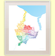
When I first moved to Rochester’s Swillburg neighborhood thirteen years ago, my favorite place to eat was Highland Park Diner. I remember this Rochester Landmarks poster, by Richard Margolis, hung over one of the booths there. I used to stare and study those landmarks all the while shoveling Aunt Bee’s Homestyle Meatloaf into my face. Ah, my first taste of Rochester. Today I own that poster, and I’ve now been to all but one of the 38 landmarks on it. It’s a great feeling!
Now you can get your hands on a copy of this Landmark poster from the RochesterSubway.com Gift Shop, and start checking them off your list too. Can you name all 38 landmarks? No peeking! The answers are after the jump…
This Wednesday night, SyFy Channel will air a new episode of Ghost Hunters featuring Rochester’s Rundel Library (and possibly the subway tunnel). Sally Snow, Assistant Director at Monroe County Library, says the show approached them initially about the abandoned Rochester subway. “As scary as the subway is, the library is where the real haunting action is,” Snow said. “All I can say is that they found stuff, for sure. I can’t say what until the show airs.”
The Ghost Hunters team spent two full nights investigating the tunnels and the Rundel building. Sally says she’s never experienced paranormal activity in the library first hand, but she has seen security camera footage of a door opening and closing by itself. “This is a door that usually requires a really good tug to get it open. It’s very strange.”
Now personally, I’m not saying I believe in this stuff, but here’s the story of one mysterious death which occurred on this very spot in 1902…
Once-in-a-lifetime opportunities don’t come along very often—that’s why they’re referred to as such. So clear your calendar, put the dog out, and grab your coat and hat… preferably a hard-hat.
After our subway excursion was squashed last Spring, many of our readers feared that they had missed their last chance to see the inside of the Rochester subway tunnel with their own eyes (and smell it with their own quivering noses). But this Summer the stars have aligned. Here come not one, not two, but THREE rare opportunities to go inside Rochester’s seldom seen subway… legally!
Oh, and did I mention, a lucky few* will get to enjoy cocktails and a catered dinner party INSIDE the tunnel? Yummy! Okay, here we go… these may be your final chances to experience the Rochester subway tunnel…
I recently invited my readers to attend a public meeting held by the City of Rochester and to make their voices heard. The purpose of the meeting was to inform the public about the Broad Street Tunnel Improvement Project which is slated to begin this Spring. The meeting was tonight and turnout was fair—not great, but I did get to meet a few RochesterSubway.com followers which was very encouraging!
Anyway, I wanted to share one opinion we got from a subscriber, Tim L., in response to our meeting announcement in which I pissed and moaned that the city failed to consider rail transit options for Broad Street. I don’t disagree with all of what Tim has to say, but I do want to hear more of your opinions on this, which is why I’m posting it here…
Recently we acquired this postcard (shown above) of the Rochester subway entrance at Court Street. And while I was reading up on the history of Rochester and the Erie Canal, I came across some pretty neat photos of downtown, the old canal, and later the construction of the Rochester Subway. These images say a thousand words so I’ll just start the slide show with this incredible panorama of Rochester from 1906…
For decades it’s been an inconvenient truth for Rochester. The abandoned Erie Canal turned ghost subway tunnel has long been considered a ticking time-bomb. It’s widely known that the city has wanted to fill at least the west end of the tunnel for many years, citing critical safety deficiencies in the structure beneath the street surface. But, with Rochester’s ongoing economic struggles and estimates into the $10’s of millions, the project has been repeatedly delayed (or swept under the rug). Until now…
ROCHESTERSUBWAY.COM: It was recently brought to our attention that the City of Rochester is taking bids from contractors to repair and/or fill the abandoned subway tunnel under Broad Street. Can you confirm this? If so, what are the details of the job?
Tom Hack: The fill is going to take place from Brown Street to the RR portal next to Nick Tahoe’s (it involves about 1900 lf out of 4600 lf total). We are maintaining the RR portal behind Nick Tahoe’s as that will serve as a new access/maintenance road into the remaining sections of the tunnel.
ROCHESTERSUBWAY.COM: When are you hoping to start the work?
Tom Hack: We are scheduled to open bids on October 19, 2009. We hope to have “actual” construction operations underway in early December 2009, however the bulk of the tasks won’t hit their stride until April-May 2010.
ROCHESTERSUBWAY.COM: What range do you expect the bids to come in at? (in $$)
Tom Hack: We anticipate that bids for the work will be in the range of $14-16 Million (+/-).
ROCHESTERSUBWAY.COM: Is this project part of a larger initiative? i.e. Is this just Phase 1 in filling the rest of the tunnel, or maybe prep work for some larger project involving Broad Street?
Tom Hack: This project is a standalone project but obviously it does has ramifications toward other city proposed initiatives. Four issues that come into play are:
Parking within the confines of the remaining rehabilitated sections of the Tunnel
Phase III and IV of Rochester’s Historic Canal District Initiative does envision partial use of this space for the creation of the West end Basin, however the timing of this phase is 15-20 years out and obviously the dynamics and market conditions may dictate other uses.
Stabilization and general enhancement of the corridor. This project does strengthen, link and unify the visual attributes of the surrounding land uses and neighborhoods. This is an overall initiative of the City and indirectly the streetscape amenities that we will be installing does add value in that regard.
The project does advance the Rochester Heritage Trail. The Rochester Heritage trail is a designated walkway linking the City’s multitude of historic feature, dating when downtown was a port on the Erie Canal and the burgeoning center of commerce, industry and social activism. This is a self guided walk that identifies historic sites and tells the stories of Rochester’s people, places, and cultures as they impacted development of our nation. (Think Boston’s Freedom Trial)
Get Email Updates...
Stay up-to-date on Rochester-related stories, artifacts, and ideas that you won't find in the mainstream news.
Totally free, never spammy, and you can unsubscribe at any time.
After the Erie Canal was rerouted south of downtown Rochester, the Rochester
Industrial & Rapid Transit Railway (the “subway”) was built in
its place as a link between the five different railroads and interurban trolley
lines that served the Rochester area. As the industrial landscape of Rochester
changed, and highways replaced the railroads, the Rochester subway gradually
became a relic of a bygone era. In 1956 the subway was abandoned and much of
its route was converted into Interstate 490 — built to connect Rochester
with the New York State Thruway (I-90). Read more about the history of the Rochester Subway.
RochesterSubway.com exists to help spark
public dialogue around how we can better connect the neighborhoods of Rochester
NY, surrounding communities, and their cultural offerings. Rochester’s
future is written in her past. Let's rediscover it.


![It is almost impossible to imagine a project like the canal ever being built in today’s political climate and maybe that is not such a good thing. In this edition of Wear to Where we stop by Lock 33 and ask, 'What’s the big idea?' [PHOTO: Clarke Condé]](https://www.rochestersubway.com/images/photos/rochester-fashion-wear-to-where-erie-canal-lock-33-01.jpg)

![Looking north through the gap in the north wall of newly completed Barge Canal. A break occurred at Bushnell's Basin on May 19, 1911. [PHOTO: Perinton Municipal Historian collection]](https://www.rochestersubway.com/images/photos/rochester-erie-canal-break-04.jpg)
![Merkel Donahue building, Oct 2014. Development Update on 210 South Avenue, Rochester NY. [PHOTO: Steve Vogt]](https://www.rochestersubway.com/images/photos/development-update-210-south-ave-rochester-ny-01.jpg)
![A large crowd is gathered on Front Street to look at the flood at the other end of the street. Varlan's Hotel, Rosenberg's Pawnshop, Charles Adam's Sons Grinding, J.G. Zweigle's Sons, W.T. Bridle Furniture, William Pigeon Shoes, Hyman Davis Shoes, Genesee Provision Company, Myers Department Store, and the F.H. Loeffler Company are visible in the photo. March, 1913. [IMAGE: Albert R. Stone]](https://www.rochestersubway.com/images/photos/rochester-ny-flood-march-1913-01.jpg)
![The fifth and final part of Ryan Green's Bike Rochester Series... the El Camino and Route 390 Trails! [PHOTO: Ryan Green]](https://www.rochestersubway.com/images/photos/rg-bike-rochester-el-camino-and-route-390-trails-014.jpg)
![Benjamin Woelk wants to produce a grassroots travel documentary series called 'Slow Road.' [PHOTO: Provided]](https://www.rochestersubway.com/images/photos/benjamin-woelk-slow-road-01.jpg)
![The fourth part of the Bike Rochester Series... let's hit the Genesee Greenway and Lehigh Valley Trails! [PHOTO: Ryan Green]](https://www.rochestersubway.com/images/photos/rgbike-rochester-genesee-valley-greenway-lehigh-valley-trail-LV101.jpg)
![In this third piece exhibiting Rochester's bicycle trails, we will be returning to the Erie Canal Heritage Trail to visit Brockport, NY. [PHOTO: Ryan Green]](https://www.rochestersubway.com/images/photos/rgbike-rochester-to-brockport-B102.jpg)
![The Ehrmentraut Farm Bridge is easily one of the oldest and most unique bridges in the entire United States. [PHOTO: Chris Clemens]](https://www.rochestersubway.com/images/photos/ehrmentraut-farm-bridge-01.jpg)
![Ryan Green takes us on a bike ride from downtown Rochester to Fairport. [PHOTO: Ryan Green]](https://www.rochestersubway.com/images/photos/rgbike-erie-canal-path-return-04.jpg)
![Plan view of proposed CityGate project. [IMAGE: AJ Costello & Son]](https://www.rochestersubway.com/images/photos/city-gate-site-plan-01.jpg)
![Rochester Landmarks Poster [IMAGE: Richard Margolis]](https://www.rochestersubway.com/images/photos/rochester-landmarks-poster-richard-margolis.jpg)


