


![Downtown Rochester from the Cascade District [PHOTO: Rochester City Hall]](https://www.rochestersubway.com/topics/wp-content/uploads/Downtown_From_Cascade.jpg)
While poking around the Rochester Image Database that the Monroe Public Library so lovingly maintains, I bumped into a series of 24 aerial photographs taken in 1982. That in and of itself wouldn’t be the most interesting thing ever, except the images portray Rochester in the middle of an incredible transition to be much closer to the city we know now than the one anyone might have recognized from before.
Posts Tagged ‘Lower Falls’...
Rochester 1982
Wednesday, October 19th, 2016Tags: BCBS, Can of Worms, Charlotte, Convention Center, Corn Hill, Corn Hill Commons, County Offices, High Falls, Hotel Rochester, implosion, Inner Loop, Lower Falls, Matt Denker, Matthew Denker, North Chestnut Street, Rochester Aerial Photography, South Wedge, Strong
Posted in Rochester History, Rochester Images | 14 Comments »
RocLinks 3/19/16
Saturday, March 19th, 2016![Cleaning at Rochester's Lower Falls [PHOTO: The Lower Falls Foundation]](https://www.rochestersubway.com/images/photos/denker/links/Cleaning_Rochester_Lower_Falls.jpg)
From local development to just plain news of the weird, here are your RocLinks for this past week…
Tags: AJ Costello & Son, architecture, City of Rochester, development, Lower Falls, Matt Denker, Matthew Denker, Rochester NY, Rose Fellowship, urban planning
Posted in Architecture, Rochester News, Urban Development | No Comments »
RocLinks 3/7/15
Saturday, March 7th, 2015![Rochester Lower Falls at Night in the Snow [PHOTO: RocPx.com]](http://rochestersubway.com/images/photos/denker/Lower_Falls_in_Snow.jpg)
From local development to just plain news of the weird, here are your RocLinks for this past week…
Tags: Benrus, Buckingham, Dominic Pane, Lower Falls, Monroe Avenue, Mr. Dominic's, Union Street, Water Street Music Hall, Wegman's
Posted in Rochester News | 7 Comments »
Historic Rochester in 3D Stereoscope
Monday, November 25th, 2013![3D Stereogram of High Falls (c.1885) [PHOTO: Rochester Public Library]](https://www.rochestersubway.com/images/photos/high-falls-rochester-1885.gif)
From the 1850’s to the 1930’s stereograms were considered cutting edge home entertainment technology. Two photos taken at the same time from slightly different angles would be view together using a special set of lenses called a stereoscope. The result would be an ever so subtle (yet mind-tingling) simulated 3D view…
Tags: Academy Building, Athenaeum Library, Chapin's monument, CJ Hayden monument, High Falls, Lake Avenue, Lower Falls, Monroe County Court House, Mount Hope Cemetery, old photos, old photos of Rochester, old photos of Rochester NY, Pitkin monument, Pitkin vault, Powers Building, Rochester, Rochester City Hall, Rochester Free Academy, Rochester NY, Sibley Building, Sibley's, Sibley's Department Store, Sibly Lindsay & Curr Co., stereogram, stereoscope, stereoscopic views, vintage views, West Main Street
Posted in Rochester History, Rochester Images | 5 Comments »
Bike Rochester: Downtown to Lake Ontario and Seabreeze
Monday, September 9th, 2013![Turning Point Park boardwalk. [PHOTO: Ryan Green]](https://www.rochestersubway.com/images/photos/rgbike-bike-to-lake-ontario-25-turning-point-park-boardwalk3.jpg)
The following is a guest post submitted by Ryan Green.
Submit your story today.
The second part of The Biking in Rochester Series showcases the route from downtown to Lake Ontario, following the Genesee River Trail. It is 20 miles, roundtrip, from downtown to the end of the pier at Lake Ontario Beach Park and back. Actually, I’ll take us a bit further and ride along the lake shore, east to Sea Breeze – adding another 8 miles to the trip.
Although this route is not as consistently scenic as the first one, it has much better rewards, and you get more of a workout. We’ll pass by 3 waterfalls, 3 beaches, 3 lighthouses, and two piers out onto the big lake. The western portion of this route is on the Genesee Riverway trail, a mostly completely dedicated bike path such as the one on the canal. The eastern portion is on King’s highway/Goodman street…
Tags: Beach Avenue, bicycle path, bike path, Brewer Street, Colonel Patrick O'Rorke Memorial Bridge, Culver Road, downtown Rochester, Durand Eastman Park, Genesee Brewery, Genesee River, Genesee Riverway Trail, Goodman Street, hidden sidewalk, High Falls, Kings Highway, Kodak Research and Development, Lake Avenue, Lake Ontario, Lower Falls, Main Street, Maplewood Park, Middle Falls, Parkside Diner & Whispering Pines Miniature Golf, Pont De Rennes Bridge, Ryan Green, Seabreeze Amusement Park, secret sidewalk, Turning Point Park, Veterans Memorial Bridge
Posted in Reader Submitted Stories, Rochester Destinations, Rochester Images, Transit + Infrastructure, Urban Exploration | 6 Comments »
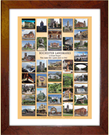
The Rochester Landmarks Poster, by Richard Margolis
Monday, March 4th, 2013![Rochester Landmarks Poster [IMAGE: Richard Margolis]](https://www.rochestersubway.com/images/photos/rochester-landmarks-poster-richard-margolis.jpg)
When I first moved to Rochester’s Swillburg neighborhood thirteen years ago, my favorite place to eat was Highland Park Diner. I remember this Rochester Landmarks poster, by Richard Margolis, hung over one of the booths there. I used to stare and study those landmarks all the while shoveling Aunt Bee’s Homestyle Meatloaf into my face. Ah, my first taste of Rochester. Today I own that poster, and I’ve now been to all but one of the 38 landmarks on it. It’s a great feeling!
Now you can get your hands on a copy of this Landmark poster from the RochesterSubway.com Gift Shop, and start checking them off your list too. Can you name all 38 landmarks? No peeking! The answers are after the jump…
Tags: Aqueduct Bridge, ARTwalk, Browns Race, Bust of Goethe, Center at High Falls, Charlotte Lighthouse, Colgate Divinity School, Cutler Union, Don’s Original, Driving Park Bridge, Eastman Theater, Erie Canal, First Universalist Church of Rochester, Genesee Brewery, Genesee River, George Eastman House, Geva Theatre, gift idea, Gift Shop, High Falls, Highland Park, Highland Park Diner, Hojack Swing Bridge, House of Guitars, Hoyt-Potter house, Jack Rabbit, Jines, Kodak World Headquarters, Lamberton Conservatory, Landmark Society, Let’s Have Tea, Little Theatre, Lower Falls, Main Street Armory, Memorial Art Gallery, Naval Armory, Nick Tahou's, Ontario Beach, Oxford Street Magnolias, Park Avenue, photo, photographer, Poet’s Garden, poster, Richard Margolis, Robach Community Center, Rochester, rochester images, Rochester Landmarks poster, Rochester NY, rochester photos, Rochester Public Market, Sacred Heart Cathedral, Sam Patch, Schoen Place, Seabreeze Amusement Park, Seneca Park, Seneca Park Zoo, Stone Tolan House, Susan B. Anthony Square, The Powers Building, Writers & Books
Posted in Art + Culture, Rochester Destinations, Rochester History, Rochester Images | 2 Comments »
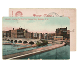
The Life and (Explosive) Death of Rochester’s Driving Park Bridge
Monday, November 19th, 2012
Last week we explored some of the caves in Rochester’s Genesee River gorge. While digging around for information about Lower Falls, I came across some great stuff on the nearby Driving Park Bridge. The bridge that you know today was built in 1989. But the previous bridge (shown above) had been there for nearly 100 years. That’s pretty remarkable when you consider its length of 717 feet, the icy Rochester weather, and the relentless spray from the Lower Falls below. Be sure to click on the image above for a much larger view. And check out the link at the end of this article to watch the explosive demolition of the old steel bridge in the 1980’s…
Tags: Avenue E, bridge, demolition, Driving Park Bridge, Genesee River, Genesee River Gorge, infrastructure, Lefferts L. Buck, Lower Falls, Niagara Falls Bridge, old photos, old photos of Rochester, Rochester, Rochester NY, Williamsburg Bridge
Posted in Rochester History, Rochester Images, Transit + Infrastructure | 14 Comments »
Exploring the Caves of Rochester, NY
Thursday, November 15th, 2012![Rico Cave in the Genesee River gorge near Lower Falls. [Flickr PHOTO: bobbybeans]](https://www.rochestersubway.com/images/photos/rochester-rico-cave-bobbybeans-1.jpg)
Just when I think I’ve done everything there is to do in Rochester, I discover another little hole in the wall. Literally. Check out these photos of what is unofficially known as “Rico Cave” near Lower Falls…
Tags: Driving Park Bridge, Genesee River, Lower Falls, Rico Cave, Rochester, rochester photos, urban exploration, urban explorers, video
Posted in Rochester Destinations, Rochester Images, Urban Exploration, Video | 35 Comments »