


![Downtown Rochester from the Cascade District [PHOTO: Rochester City Hall]](https://www.rochestersubway.com/topics/wp-content/uploads/Downtown_From_Cascade.jpg)
While poking around the Rochester Image Database that the Monroe Public Library so lovingly maintains, I bumped into a series of 24 aerial photographs taken in 1982. That in and of itself wouldn’t be the most interesting thing ever, except the images portray Rochester in the middle of an incredible transition to be much closer to the city we know now than the one anyone might have recognized from before.
Posts Tagged ‘Charlotte’...
Rochester 1982
Wednesday, October 19th, 2016Tags: BCBS, Can of Worms, Charlotte, Convention Center, Corn Hill, Corn Hill Commons, County Offices, High Falls, Hotel Rochester, implosion, Inner Loop, Lower Falls, Matt Denker, Matthew Denker, North Chestnut Street, Rochester Aerial Photography, South Wedge, Strong
Posted in Rochester History, Rochester Images | 14 Comments »
RocLinks 7/2/16
Saturday, July 2nd, 2016![MLK Park née Manhattan Square Park Playground in 1983 [PHOTO: City Hall Photo Lab contemporary collection]](https://www.rochestersubway.com/topics/wp-content/uploads/Manhattan_Square_Park.jpg)
From local development to just plain news of the weird, here are your RocLinks for this past week…
Tags: Charlotte, e-bikes, Eastman Dental Dispensary, Edgewater, Halprin, Matt Denker, Matthew Denker, Maxwell Motorbikes, Mezcal, MLK Park, RocLinks, The Revelry, Troy Rank
Posted in Architecture, Rochester News, Urban Development | 2 Comments »
A History of the Charlotte Lighthouse
Tuesday, December 8th, 2015![The Charlotte lighthouse in summer, 2014. [PHOTO: Joanne Brokaw]](https://www.rochestersubway.com/images/photos/rochester-charlotte-lighthouse-01.jpg)
If there’s a cemetery tour happening in Rochester, you can be sure I’m there. For anyone interested in local history, there’s no better place to find unusual stories and bits of trivia, and I’m fascinated by the history buried all around us.
A few weeks ago, the City of Rochester hosted the annual Genesee River Romance weekend ![]() celebrating the Genesee River and its surrounding trail and gorge system. In 2014, I took full advantage of the weekend of events that include tours of the old subway and aqueducts, the Rundel Library, the Falls, and cemeteries. Somehow, I missed the adverts for this year’s event, so I only had time to catch one thing: the tour of Charlotte Cemetery…
celebrating the Genesee River and its surrounding trail and gorge system. In 2014, I took full advantage of the weekend of events that include tours of the old subway and aqueducts, the Rundel Library, the Falls, and cemeteries. Somehow, I missed the adverts for this year’s event, so I only had time to catch one thing: the tour of Charlotte Cemetery…
Tags: Charlotte, Charlotte Beach, Charlotte Cemetery, Charlotte Coast Guard, Charlotte Lighthouse, Cuyler Cook, David Denman, first child born in Rochester NY, Genesee River, Giles Holden, history of Rochester, Holden Street, Jack Kemp, James Stoddard Stone, Joanne Brokaw, Lake Avenue, Lake Ontario, Latta family, Luther Jeffords, Mehitabel Hincher, Oak Orchard, River Romance, Rochester, Rochester history, Rochester NY, Sam Patch, Sam Phillips, Shay's Rebellion, Sodus Bay, the Lighthouse Act, Thomas Jefferson, U.S. Coast Guard, William Hincher
Posted in Other | Comments Off on A History of the Charlotte Lighthouse
Rochester’s Changing Landscape
Tuesday, August 25th, 2015![Satellite before & after image of Rochester. [IMAGE: Google Earth via Nick Russo]](https://www.rochestersubway.com/images/photos/rochester-satellite-before-and-after-midtown-plaza.gif)
The following is a guest post submitted by Nick Russo.
Submit your story today.
I’ve always been a fan of Rochester Subway content which looks at our city from a different angle. I thought I might contribute something in turn, that looks at our city from an aerial angle.
I noticed this week that Google Earth had updated its imagery to include snapshots from as early as a month ago. It is now possible to follow a lot of tangible changes that have been going on in the city for a while. I put together a handful of before-and-afters ![]() that I thought were interesting (to me anyway). Take a look at the album and see if you can spot the differences…
that I thought were interesting (to me anyway). Take a look at the album and see if you can spot the differences…
Tags: Carnegie building, Charlotte, CityGate, Collegetown, dredging, Eastman Business Park, Golisano Children's Hospital, Google Earth, Google Street View, I-390, Inner Loop, Interstate 390, Kodak building 53, Kodak implosion, Kodak Park, Midtown Plaza, Nicholas Russo, Nick Russo, Port of Rochester, RIT Gene Polisseni Center, Rochester, Rochester before and after photos, Rochester Institute of Technology (RIT), Rochester NY, satellite image
Posted in Reader Submitted Stories, Rochester Images, Transit + Infrastructure, Urban Development | 4 Comments »
Rochester’s Carousel is “Not Garbage Art”
Sunday, August 9th, 2015![This painted picaninny panel on Rochester's Dentzel carousel has been the subject of debate since the confederate flag was removed from South Carolina's State House in July. [IMAGE: RochesterSubway.com]](https://www.rochestersubway.com/images/photos/rochester-ontario-beach-carousel-04.jpg)
By Mike Governale with help from Carlie Fishgold.
In 1867 Gustav Dentzel founded the Dentzel Carouse Company in Philadelphia, PA. In 1905, Gustav’s “Duchess” menagerie carousel opened at Ontario Beach Park where it has since entertained many generations of Rochesterians.
Recently, a debate has erupted concerning one of the ride’s painted panels; two black children—or more accurately, picaninnies—being harassed by a rooster. Stereotypical depictions of black children such as these were intended to dehumanize blacks and provide entertainment for whites at their expense. There’s no debate here. It is what it is. The question is what do to with the panel…
Some have called for it to be removed or replaced with something different. Others believe it should be preserved – either in place, or in another setting where it can be used to educate future generations about America’s history and the pitfalls of racism and bigotry.
Bill Dentzel is the great-grandson of Gustav Dentzel. In a letter to Rochester’s Preservation Board dated August 4, 2015, Bill suggests that the panel may be moved, but should not be discarded as “garbage”…
Tags: African-American, Bill Dentzel, Charlotte, Charlotte Beach, Dentzel carousel, Dentzel Carousel Company, Edward P. Dentzel, Gustav Dentzel, historic preservation, Monroe County, Ontario Beach Park, Ontario Beach Park carousel, picaninny, preservation, race in Rochester NY, racism, Rochester, Rochester NY, Rochester Preservation Board, slavery, William H. Dentzel
Posted in Art + Culture, Opinion, Reader Submitted Stories, Rochester Destinations, Rochester History, Rochester News | 15 Comments »
A Carousel of Debate: The Preservation of Ridicule
Friday, August 7th, 2015![Dentzel carousel at Ontario Beach Park. Rochester, NY. [IMAGE: RochesterSubway.com]](https://www.rochestersubway.com/images/photos/rochester-ontario-beach-carousel-01.jpg)
The following is a guest post submitted by Carlie Fishgold, Associate Editor at POST Magazine and Independent Scholar. Submit your story today.
For those in the Rochester community who have a hard time understanding why the Dentzel carousel painted picaninny panel disallows African-American families and children from a carefree experience at Ontario Beach Park, I encourage you consider that you are not the butt of the joke…
Tags: African-American, Carlie Fishgold, Charlotte, Charlotte Beach, Dentzel carousel, historic preservation, Landmark Society of Western New York, Monroe County, Ontario Beach Park, Ontario Beach Park carousel, picaninny, preservation, race in Rochester NY, racism, Rochester, Rochester NY, Rochester Preservation Board, slavery
Posted in Art + Culture, Opinion, Reader Submitted Stories, Rochester Destinations, Rochester History, Rochester News | 39 Comments »
The Glen House – Rochester’s First Water-side Retreat
Monday, April 27th, 2015![In 1870 Ellwanger & Barry (and other wealthy investors) owned a spot along the west bank of the Genesee River gorge known as Maple Grove. At the time, the Lake Avenue streetcar line stretched all the way to this point, and in an effort to stimulate traffic on the trolley line, they had built Rochester's first water-side resort; the Glen House. [PHOTO: 'Rochester's Lakeside Resorts and Amusement Parks' by Donovan Schilling]](https://www.rochestersubway.com/images/photos/glen-house-rochester-ny-01.jpg)
In 1870 Ellwanger & Barry (and other wealthy investors) owned a spot along the west bank of the Genesee River gorge known as Maple Grove. At the time, the Lake Avenue streetcar line stretched all the way to this point, and in an effort to stimulate traffic on the trolley line, they had built Rochester’s first water-side resort; the Glen House…
Tags: Charlotte, City of Rochester Steamboat, Eastman Kodak, Ellwanger-Barry, Genesee River, Genesee River Gorge, Glen House, history of Rochester, Kodak Park, Lake Avenue, Lake Ontario, Lake Ontario Steamboat Company, Maple Grove, Maplewood Park, old photos of Rochester, old photos of Rochester NY, Ontario Beach Park, riverboat, Rochester, Rochester history, Rochester NY, Seabreeze, Sylvan Stream
Posted in Architecture, Rochester Destinations, Rochester History, Rochester Images, Transit + Infrastructure, Urban Exploration | 11 Comments »
Edgewater Developer Walks Us Through Rochester’s Port Project
Monday, June 23rd, 2014
You’ve read about it. You’ve heard plenty of commentary about it. And if you’re like me, you still have plenty of questions about the Port of Rochester development. This past weekend Greg Weykamp, owner of Edgewater Resources, LLC spent an hour with me on site to answer my questions on everything from the design of the marina & proposed development, accessibility, marketability, and parking/traffic concerns.
In this six-part video series, Weykamp addresses many of the concerns expressed by Charlotte neighbors over the past few months. No doubt there will still be more questions as the project enters the design phase. But his willingness to spend time with me (and my two kids who are dancing around in the background) showed me that this may not be the monster some people have made him out to be ![]() . But you can watch for yourself, and please let me know what you think…
. But you can watch for yourself, and please let me know what you think…
Tags: Charlotte, develo, development plans, Edgewater Resources LLC, Greg Weykamp, Ontario Beach Park, Port of Rochester, Rochester, urban development, video
Posted in Interviews, Rochester Destinations, Rochester News, Transit + Infrastructure, Urban Development | 93 Comments »
Filling In: Charlotte Part 3
Tuesday, May 20th, 2014
The following is a guest post submitted by Matthew Denker.
Submit your story today.
Welcome back to our three part series on Charlotte. We’ve arrived at part three. This is it, the omega. If you recall, all the way back in part one, we said this part would be broken up into three sections:
1. Residential and Commercial Development;
2. Transportation; and
3. Governance.
So without further adieu, let’s jump right in. Ok, one quick disclaimer, Charlotte as a whole is pretty big, too big for one little three part column. With that in mind, I’m cutting off Charlotte at Denise Road, similar to the other parts. Maybe someday I can write an addendum addressing the southern portion of the neighborhood. But enough of that – Onward!
Tags: Charlotte, development, Filling In, Matthew Denker, Port of Rochester/Charlotte, Rochester, Rochester NY, urban development
Posted in Opinion, Reader Submitted Stories, Rochester News, Urban Development | 44 Comments »
Filling In: Charlotte Part 2
Thursday, May 8th, 2014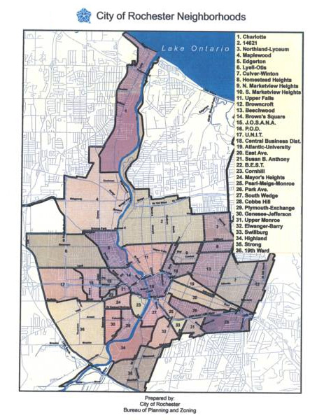
The following is a guest post submitted by Matthew Denker.
Submit your story today.
In part one of our three part Charlotte bonanza, we looked briefly at the history of Charlotte, from its formation in 1792, through its resort years and annexation in the early 20th century. In part two, we’ll look at Charlotte as it is today. Let’s start with the lay of the land. Shown above is the official definition of the city’s neighborhoods. As you know, Charlotte is the one at the top. Zooming in (and switching to Google maps) here’s what we see…
Tags: Charlotte, Filling In, Filling In Charlotte, Matthew Denker, Port of Rochester/Charlotte, Rochester, Rochester history, Rochester NY
Posted in Reader Submitted Stories, Rochester History, Urban Development | 7 Comments »
Filling In: Charlotte, Part 1
Wednesday, April 30th, 2014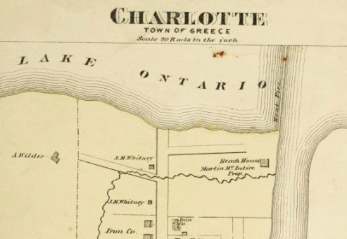
The following is a guest post submitted by Matthew Denker.
Submit your story today.
Welcome, readers, to the first of a three part series on Charlotte. This first part will serve as an introduction to the series and a brief history of Charlotte. The second part will be a survey, in the engineering sense, of the current state of Charlotte. It will include the demographics of the neighborhood and the built environment, as they exist today. Finally, the third part will layout a vision for Charlotte that works to harness all of the potential of the neighborhood. This final part will be broken into recommendations for residential and commercial development, transportation, and governance.
The plans described here will be ambitious, but we shouldn’t let ourselves shy away from ambition – as you may know, Charlotte has recently been in the news ![]() over some redevelopment plans. While Filling-In believes both plans have virtues, they both have numerous weaknesses as well. Because we are unassociated with any of the plans currently in play, and will believe they are built when we see it, the plans presented here will assume they did not happen, and instead will show a different vision of Charlotte’s future.
over some redevelopment plans. While Filling-In believes both plans have virtues, they both have numerous weaknesses as well. Because we are unassociated with any of the plans currently in play, and will believe they are built when we see it, the plans presented here will assume they did not happen, and instead will show a different vision of Charlotte’s future.
But now, we present a brief history of Charlotte.
Tags: Beach Avenue, Charlotte, Charlotte Beach, Filling In, Filling In Charlotte, Lake Avenue, Matthew Denker, old photos, old photos of Rochester NY, Ontario Beach, Ontario Beach Park, Port of Rochester/Charlotte, Rochester, Rochester history, Rochester NY
Posted in Reader Submitted Stories, Rochester History, Urban Development | 30 Comments »
New Exhibit Honors the Hojack Swing Bridge
Monday, April 28th, 2014![The control room of the Hojack Swing Bridge has been recreated at the NY Museum of Transportation. [PHOTO: Flickr, M J M]](https://www.rochestersubway.com/images/photos/hojack-swing-bridge-mjm.jpg)
Rochester’s beloved Hojack Swing Bridge has been gone for more than a year, but now a new exhibit at the New York Museum of Transportation will honor the history of the former Rochester landmark. The exhibit is a re-creation of the bridge’s control cabin and contains the original steam engine, control devices, and a working model of the bridge…
Tags: Charlotte, demolition, Genesee River, Hojack Railroad Line, Hojack Swing Bridge, New York Museum of Transportation (NYMT), Port of Rochester, Rochester, Rochester NY, rochester photos
Posted in Rochester History, Rochester Images, Rochester News, Train/Railroad Stuff, Transit + Infrastructure | 3 Comments »
Fighting the Flames at Ontario Beach Park
Monday, April 28th, 2014
No, the headline isn’t in reference to the recent controversy surrounding the port development. I wanted to take a look back, at the “good ole days,” when Ontario Beach was known as the Coney Island of central and western New York. Here’s a birds eye of view of all the shiny happy fun… The Dentzel carousel. The L.A. Thompson’s Scenic Railway. The Auditorium (a.k.a. the House of Hilarity). Such good times.
Then I noticed the peculiar site of smoke and flames in the background (click the image for a larger view). Holy smokes! Charlotte is burning! Somebody call 9-1-1!!
Tags: carousel, Charlotte, Charlotte Beach, Donovan A. Shilling, Livingston Hotel, Messmore's Fighting the Flames, Ontario Beach, Ontario Beach Park, Ontario Hotel, Port of Rochester/Charlotte, Rochester, Rochester history, Rochester NY, The House That Jack Built crazy house
Posted in Rochester Destinations, Rochester History, Rochester Images | 1 Comment »
NIMBY’s to left of me, NIMBY’s to the right
Wednesday, April 16th, 2014
The following is a guest post submitted by Matthew Denker.
Submit your story today.
Ok, so by now you’ve heard all the commotion happening up near the port at Charlotte. The City of Rochester has two development proposals – one with 200 rental apartments, and one with 120 for-sale condos and 50 townhomes. Both would have retail and other mixed use space. But the BIG difference, one looks like Cornhill Landing, while the other would have—deep breath—tall buildings…
Tags: brownfield development, Charlotte, Charlotte Beach, City of Rochester, development plans, Edgewater Resources, Lighthouse Landing, Matthew Denker, Morgan Development, Ontario Beach, Port of Rochester/Charlotte, Rochester, Rochester NY, urban development, Waterfront Rochester
Posted in Reader Submitted Stories, Urban Development | 68 Comments »
It’s Dead
Wednesday, January 22nd, 2014
Sorry. I didn’t mean to scare you with the alarming headline, but the traffic-calming project that was proposed for Lake Avenue (at Holy Sepulchre Cemetery) is dead. I received word yesterday from a friend in Charlotte that Mayor Lovely Warren has ordered City engineers to kill the planned lane reduction. Warren caved in to pressure from Charlotte residents & merchants who feared the lane reduction would cause traffic jams and hurt businesses in Charlotte.
In addition to reconstructing the 1 mile section of Lake Avenue, the plan would have reduced the lanes from four to three – with one lane in each direction plus a center turn lane. Why would the City take away traffic lanes?! Relax, you don’t have to worry about it anymore…
Tags: Charlotte, City of Rochester, Holy Sepulchre Cemetery, Joe Robach, Lake Avenue, Lake Avenue Improvement Project, petition, Rich Koss, Riverside Cemetery, Senator Joseph Robach, St. Bernard's Park
Posted in Opinion, Rochester News, Transit + Infrastructure | 27 Comments »
Rochester’s Lakeshore Drive-in Theatre May Get New Life
Wednesday, January 15th, 2014![The marquee sign at the former Lakeshore Drive-in Theatre in Greece, NY. [PHOTO: NewYorkDriveIns.com]](https://www.rochestersubway.com/images/photos/rochester-lakeshore-drive-in-movie-theater-marquee.jpg)
Last month RocSubway Facebook fans brought us rumors of a new grocery store for downtown Rochester (those rumors turned out to be true). Now comes an equally exciting rumor from RocSubway that has also checked out. John Tachin, owner of Mr. Dominic’s restaurant in Charlotte has purchased the former Lakeshore Drive-In site and is considering plans to reopen it as a drive in movie theater…
Tags: Avon NY, Charlotte, Dominic Pane, Greece, Jetset Development Inc., John Tachin, Lakeshore Drive-in Theatre, Ling Road, Mr. Dominic's, Mr. Dominic's at the Lake, old movie theater, Port of Rochester/Charlotte, Rochester, Rochester NY, Vintage Drive In
Posted in Interviews, Rochester History, Rochester Images, Urban Development, Urban Exploration | 21 Comments »
Tell Senator Robach We Actually WANT Safer Streets…
Thursday, January 2nd, 2014
Drivers who like to speed their cars down Lake Avenue between Charlotte and the city have found a new enemy in the Lake Avenue Improvement Project ![]() . The plan aims to reduce automobile speeds to better match the posted speed limit of 35 mph by reducing the number lanes. It would also add safety features for pedestrians, cyclists and transit users. But some drivers in the Charlotte neighborhood say the plan will only serve to cause traffic jams and they’ve called on Senator Joe Robach to block it.
. The plan aims to reduce automobile speeds to better match the posted speed limit of 35 mph by reducing the number lanes. It would also add safety features for pedestrians, cyclists and transit users. But some drivers in the Charlotte neighborhood say the plan will only serve to cause traffic jams and they’ve called on Senator Joe Robach to block it.
If you are a pedestrian… a cyclist… someone who’s ever walked to a bus stop… or a driver who likes the idea of making our streets safer for everyone, you might want to sign this petition ![]() in support of the project. And please go ahead and share the link with a few friends.
in support of the project. And please go ahead and share the link with a few friends.
Tags: Charlotte, City of Rochester, Holy Sepulchre Cemetery, Joe Robach, Lake Avenue, Lake Avenue Improvement Project, petition, Rich Koss, Riverside Cemetery, Senator Joseph Robach, St. Bernard's Park
Posted in Rochester News, Transit + Infrastructure | 19 Comments »
Sand Sculpting at Charlotte Beach, 1922
Friday, June 28th, 2013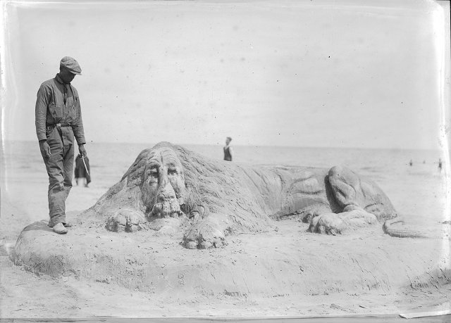
How’s this for a summertime Fun Foto Friday? This is Robert Pernell. He’s a sand artist. Or was. This photo was printed in the Rochester Herald on August 6, 1922. Robert used to entertain the crowds at Charlotte Beach with his larger-than-life creations…
Tags: Atlantic City, Charlotte, Charlotte Beach, Fun Foto Friday, history of Rochester, old photos, old photos of Rochester, Ontario Beach, Ontario Beach Park, Robert Pernell, Rochester, Rochester history, rochester images, Rochester NY, sand art, sand sculpture, World Championship of Sand Sculpting
Posted in Art + Culture, Rochester History, Rochester Images | 2 Comments »
New Aerial Photo of Hojack Swing Bridge
Friday, January 18th, 2013![Old site of the Hojack Swing Bridge near the Port of Rochester. [AERIAL PHOTO: Bob Biakowski]](https://www.rochestersubway.com/images/photos/Swing-Bridge-Aerial-Photo-Bob-Biakowski.jpg)
Today’s Fun Foto Friday may not be very fun for rail fans and admirers of the old Hojack Swing Bridge near the Port of Rochester. This is an aerial photo of where the bridge used to be. The shot was taken just a few days ago, on January 14, by Bob Biakowski. Here’s what it looked like before it was dismantled…
Tags: aerial photography, Charlotte, demolition, Fun Foto Friday, Genesee River, Hojack Railroad Line, Hojack Swing Bridge, King Bridge Company, New York Central Railroad, photo, Port of Rochester, Rochester, Rochester NY, rochester photos, Rome, Watertown and Ogdensburg Railroad (RW&O)
Posted in Rochester Images, Rochester News, Train/Railroad Stuff | 4 Comments »
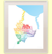
New Maps of Rochester’s Neighborhoods
Monday, August 27th, 2012![Rochester Neighborhoods Map [BY: RochesterSubway.com]](https://www.rochestersubway.com/images/photos/rochester-neighborhoods-map.jpg)
Now you can admire your hometown of Rochester, NY and the diversity of its many communities without ever putting on a pair of pants.* Introducing two awesome new posters depicting the neighborhoods of Rochester…
Tags: 14621, 19th Ward, Alexander, Beechwood, Brown Square, Browncroft, Bulls Head / B.E.S.T., Cascade District, Charlotte, Cobbs Hill, Corn Hill, downtown Rochester, Dutchtown, East Avenue, East End, Edgerton, Ellwanger-Barry, Four Corners, Genesee-Jefferson / S.W.A.N., Grove Place, High Falls, Highland, Homestead Heights, J.O.S.A.N.A., Lincoln Park / U.N.I.T., Lyell-Otis, Main & Clinton, Manhattan Square, Maplewood, Mayor's Heights / C.O.T.S., Monroe Village, Neighborhood of the Arts, neighborhoods, North Marketview Heights, North Winton, Northland-Lyceum, Park Avenue, Plymouth-Exchange, Rochester, Rochester neighborhoods, Rochester New York, Rochester NY, Saint Joseph's, Saint Paul Quarter, South Marketview Heights, South Wedge, Strong-Mt. Hope, Susan B. Anthony, Swillburg, Upper Falls, Upper Monroe, Wadsworth Square, Washington Square
Posted in Rochester Gifts, Rochester History, Rochester Images, Rochester News | No Comments »