I’ve always been a fan of Rochester Subway content which looks at our city from a different angle. I thought I might contribute something in turn, that looks at our city from an aerial angle.
I noticed this week that Google Earth had updated its imagery to include snapshots from as early as a month ago. It is now possible to follow a lot of tangible changes that have been going on in the city for a while. I put together a handful of before-and-afters that I thought were interesting (to me anyway). Take a look at the album and see if you can spot the differences…
You’ve read about it. You’ve heard plenty of commentary about it. And if you’re like me, you still have plenty of questions about the Port of Rochester development. This past weekend Greg Weykamp, owner of Edgewater Resources, LLC spent an hour with me on site to answer my questions on everything from the design of the marina & proposed development, accessibility, marketability, and parking/traffic concerns.
In this six-part video series, Weykamp addresses many of the concerns expressed by Charlotte neighbors over the past few months. No doubt there will still be more questions as the project enters the design phase. But his willingness to spend time with me (and my two kids who are dancing around in the background) showed me that this may not be the monster some people have made him out to be . But you can watch for yourself, and please let me know what you think…
Rochester’s beloved Hojack Swing Bridge has been gone for more than a year, but now a new exhibit at the New York Museum of Transportation will honor the history of the former Rochester landmark. The exhibit is a re-creation of the bridge’s control cabin and contains the original steam engine, control devices, and a working model of the bridge…
Today’s Fun Foto Friday may not be very fun for rail fans and admirers of the old Hojack Swing Bridge near the Port of Rochester. This is an aerial photo of where the bridge used to be. The shot was taken just a few days ago, on January 14, by Bob Biakowski. Here’s what it looked like before it was dismantled…
Get Email Updates...
Stay up-to-date on Rochester-related stories, artifacts, and ideas that you won't find in the mainstream news.
Totally free, never spammy, and you can unsubscribe at any time.
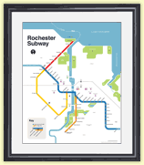
After the Erie Canal was rerouted south of downtown Rochester, the Rochester
Industrial & Rapid Transit Railway (the “subway”) was built in
its place as a link between the five different railroads and interurban trolley
lines that served the Rochester area. As the industrial landscape of Rochester
changed, and highways replaced the railroads, the Rochester subway gradually
became a relic of a bygone era. In 1956 the subway was abandoned and much of
its route was converted into Interstate 490 — built to connect Rochester
with the New York State Thruway (I-90). Read more about the history of the Rochester Subway.
RochesterSubway.com exists to help spark
public dialogue around how we can better connect the neighborhoods of Rochester
NY, surrounding communities, and their cultural offerings. Rochester’s
future is written in her past. Let's rediscover it.


![Satellite before & after image of Rochester. [IMAGE: Google Earth via Nick Russo]](https://www.rochestersubway.com/images/photos/rochester-satellite-before-and-after-midtown-plaza.gif)
![RocLinks for 1/3/15. [PHOTO: liz west, Flickr]](http://rochestersubway.com/images/photos/roclinks-2015-01-03.jpg)

![The control room of the Hojack Swing Bridge has been recreated at the NY Museum of Transportation. [PHOTO: Flickr, M J M]](https://www.rochestersubway.com/images/photos/hojack-swing-bridge-mjm.jpg)
![Old site of the Hojack Swing Bridge near the Port of Rochester. [AERIAL PHOTO: Bob Biakowski]](https://www.rochestersubway.com/images/photos/Swing-Bridge-Aerial-Photo-Bob-Biakowski.jpg)