RG&E’s Beebee power plant was one of the most formidable structures in Rochester. For half a century, this cluster of buildings covered an 8 acre site along the floor of the High Falls gorge – climbing up the west rock wall and looming hundreds of feet in the air over Platt Street and the neighborhood below…
When the world’s first elevated highway was completed in 1936 along Manhattan’s west side, the New York Times marveled that “the gleaming new concrete ribbon” would let drivers travel from lower Manhattan “nearly to Poughkeepsie without having to stop for a traffic light or slow up for an intersection.” Legendary city planner and master highway builder, Robert Moses promised the new highway would “eliminate” traffic jams on the city’s west side…
I received an email last week from George Conboy, Chairman of Brighton Securities. He asks, “Have you seen anywhere a photo of the transportation mural that was behind the long ticket counter at the old airport? I remember it as a vaguely Art Deco theme of general transportation with an emphasis, of course, on air transport.”
Mr. Conboy explained that he used to fly a lot during the “glory days” of air travel back in the 1960s when he was a kid. “I just liked that old mural. I used to see it all the time and it has always been in my mind.”
This is a great question. I had been told of this mural before but have never seen it myself. Photos of it online are practically non-existent, so this one will require some digging…
I noticed grass growing on the piles of dirt in the Inner Loop construction project today. It’s as if nature can’t wait for the filling in of the Inner Loop to complete before reclaiming the land…
A few weeks ago we took you on a trip to Van Lare Wastewater Treatment Facility to see where Rochester’s dirty water goes to get cleaned up. It was there that we learned of an extensive deep rock tunnel system that that captures major storm runoff until it can be treated. Known as the Combined Sewer Overflow Abatement Program, or CSOAP, this system saves over 1 billion gallons of sewage from overflowing into the Genesee River and Irondequoit Bay each year.
More importantly, this means there are 30 miles of giant smelly tunnels beneath our city just waiting to be explored! Come on let’s go…
Joe Henderson (34) was an earth science teacher at Rush Henrietta Central School District before graduating last year from University of Rochester with a Ph.D. in Education – with a focus on environmental education. Joe has taken many 8th graders on field trips to Frank E. Van Lare Wastewater Treatment Facility . And today, he’s arranged to bring all of you, RocSubway friends…
Density of people is good for cities. Density of cars is not . More people create more demand for local shops and services, which, in return, attract more people. Businesses seeking talent are attracted as well, and the city benefits from increased sales and property tax revenue and by increased utilization of its existing infrastructure. On the other hand when a lot of people are living in a small area, and all of those people own cars, we run out of places to put them. A winter like this one just makes us feel the pain a little more…
Protected bike lanes for the full length of Main Street. This was the request from local cycling advocate Harvey Botzman in an email late last week to City officials and other cycling advocates. The east end of Main Street in downtown Rochester is about to undergo a complete reconstruction, but bike lanes aren’t part of the plan. Additionally, the City is working on a plan to improve pedestrian connections and enhance the stretch of East Main Street between the Public Market and Neighborhood Of The Arts.
So with Main Street under the microscope, now is the time for all of us to demand, not ask, for a healthier mix of transportation options and amenities for Main Street. Harvey is leaving no gray area. He’s calling for “protected bike lanes for the full length of Main St. from Winton Rd. to Mt. Read Blvd.” and here’s why…
On May 19, 1911, a 150 foot long break occurred in the wall of the New York State Barge Canal at Bushnell’s Basin. Construction on this section of canal had just been completed eight days earlier.
According to an article in the Monroe County Mail, it was a canal worker, John McCarthy, who at 4pm discovered water pouring through a narrow crack in the canal bank…
The erosion of a former barrier beach at the Braddock Bay outlet has caused silt to collect in the mouth of the bay, impacting channel navigation for boaters. The shrinking bay is also being over run with cattails which as led to the displacement of various native plants and wildlife. In an attempt to restore the bay, the Buffalo-based U.S. Army Corps of Engineers is considering a plan to build up a new barrier beach and construct a new breakwall.
Last spring Senator Chuck Schumer urged the EPA to fund the $9 Million project, saying the plan would help open navigation channels for boaters, create new fish spawning areas for game fishing, and protect local wetlands & wildlife. The Senator also points out that property values for the nearly 100 homes on the bay are also at stake.
But not everyone is in favor of the engineering plan. Last week, Barbara Carder of Hilton wrote in to express her concern over the issue. She’s asking for people to attend a public meeting this Wednesday…
Welcome readers. I’m going on a slight deviation from my usual “Filling In” article to talk about the mean streets of Rochester. Let’s take a look at, eh, Main St. Yeah, Main St. What’s that looks like? Ok, well, there’s some tall(ish) buildings built to the street. There’s sidewalk, theoretically two driving lanes in each direction, and (supposedly) some street trees. If I were to give this street a grade, it would get an “in-complete.”
Oy, how I wish I could reconfigure things! Just pick stuff up and move it around. Maybe add a cycle track or a tree-lined median. Heh heh… can you say, STREET REMIX?!
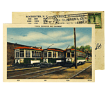
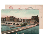
Last week we explored some of the caves in Rochester’s Genesee River gorge. While digging around for information about Lower Falls, I came across some great stuff on the nearby Driving Park Bridge. The bridge that you know today was built in 1989. But the previous bridge (shown above) had been there for nearly 100 years. That’s pretty remarkable when you consider its length of 717 feet, the icy Rochester weather, and the relentless spray from the Lower Falls below. Be sure to click on the image above for a much larger view. And check out the link at the end of this article to watch the explosive demolition of the old steel bridge in the 1980’s…
It’s no secret that I am wholeheartedly in favor of removing Rochester’s Inner Loop roadway which encircles downtown and chokes it off from the surrounding neighborhoods like an ever tightening noose. What we didn’t know until today was that City Council and Mayor Tom Richards feel the same…
Last summer I posted a progress report on Rochester’s Bike Master Plan and I commented on the importance of such planning—even if you don’t own a bike. Well, I’m all giddy with excitement to report… Rochester has a bike plan! Officially.
Something outstanding is happening in our community—Rochester is catching Bike Fever. Over the past decade or more Monroe County and local municipalities have been steadily making investments in existing off-road trails and in new ones, especially around our colleges, universities and along the river and lake shore. You may have noticed some new ones near you. Bicycling Magazine even placed Rochester on their list of America’s Top 50 Bike-Friendly Cities this year. Albeit at #50, but hey, it’s a good start!
A recent story in the City Newspaper, “Glamming Rochester’s Gateways” touched on the idea that filling in part of the Inner Loop would help reconnect certain neighborhoods with downtown and improve Rochester’s eastern gateways. Then came the raging comments from readers who blindly defended the inner loop and its many blessings.
One letter sent in from James R. Boehler went like this… (more…)
To view this site, you need to have Flash Player 9 or later installed. Click here to get the latest Flash player.
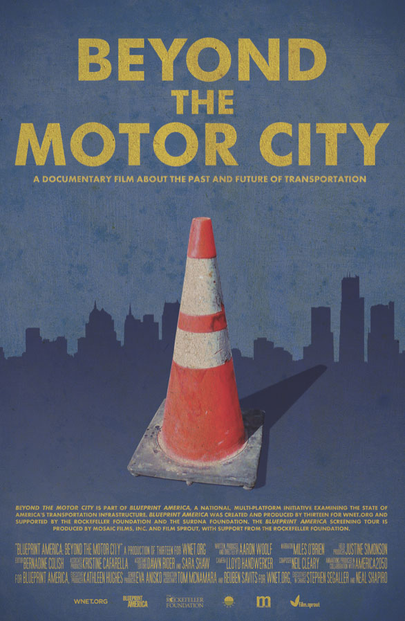
On Monday June 28 at 7:00pm you are invited to a FREE screening of PBS’s eye-opening film, BLUEPRINT AMERICA: BEYOND THE MOTOR CITY. The documentary is touring cities across America to raise questions—and seek answers—about the future of transportation in America. Can we build the “infrastructure of tomorrow” today? Can the cash-strapped and car-dependent cities of the so-called Rust Belt become new models for fast, clean, public transit? The links and similarities between Rochester NY and Detroit MI are glaringly obvious—and I think you owe it to yourself to see this film.
America seems to have taken a renewed interest in mobility. Maybe due to President Obama’s recent commitment to high speed rail—or perhaps the positive results seen in towns like Portland and Denver have caught our collective attention. Whatever the reason, from the top down, people are rethinking our automobile-oriented culture—and getting excited about the possibilities.
There’s also good reason to focus on transportation as a way of jump-starting economic development. Industry requires access to people. And people need to have easy access to centers of employment. Continually improving access makes further development possible. Interrupting access will have the opposite effect. Likewise, doing nothing or simply maintaining existing infrastructure for an extended period of time will also hinder development.
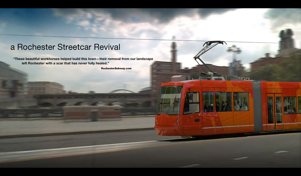
For 30+ years Rochester has relied on the infrastructure choices it made in the 1950’s, 60’s, and 70’s. At that time we made development choices that encouraged our population to emigrate from the downtown core. We scrapped our extensive streetcar system, choked off downtown with the construction of the inner-loop, and paved super highways to take us from the city to the NY State Thruway and beyond. Since then that’s exactly where our money, our workforce, and our future have gone—down I-490 and out of state.
Similar to how the Interstates reshaped America 50 years ago, the Chinese landscape is now being reshaped by historic levels of infrastructure spending. While the U.S. government seeks to revive it’s struggling economy in part by spending billions on shovel-ready, band-aid projects (i.e. re-surfacing roads), it seems Beijing’s goal is to put 26 million Chinese to work building new high-speed rail connections between its cities.
Get Email Updates...
Stay up-to-date on Rochester-related stories, artifacts, and ideas that you won't find in the mainstream news.
Totally free, never spammy, and you can unsubscribe at any time.
After the Erie Canal was rerouted south of downtown Rochester, the Rochester
Industrial & Rapid Transit Railway (the “subway”) was built in
its place as a link between the five different railroads and interurban trolley
lines that served the Rochester area. As the industrial landscape of Rochester
changed, and highways replaced the railroads, the Rochester subway gradually
became a relic of a bygone era. In 1956 the subway was abandoned and much of
its route was converted into Interstate 490 — built to connect Rochester
with the New York State Thruway (I-90). Read more about the history of the Rochester Subway.
RochesterSubway.com exists to help spark
public dialogue around how we can better connect the neighborhoods of Rochester
NY, surrounding communities, and their cultural offerings. Rochester’s
future is written in her past. Let's rediscover it.


![RG&E Beebee power station prior to demolition. Rochester, NY. Summer 2016. [IMAGE: Anonymous]](https://www.rochestersubway.com/images/photos/rochester-rge-beebee-station-00.jpg)

![Do you remember the mural at the old Rochester Monroe County Airport? A reader asked if we could share photos of it. [IMAGE: Rochester Public Library Local History Division]](https://www.rochestersubway.com/images/photos/rochester-monroe-county-airport-00.jpg)
![I noticed grass growing on the piles of dirt in the Inner Loop construction project today. It’s as if nature can’t wait for the filling in of the Inner Loop to complete before reclaiming the land. [PHOTO: Matthew Ehlers]](https://www.rochestersubway.com/images/photos/rochester-innerloop-fill-grass.jpg)
![Let's explore Rochester's deep rock sewer tunnels! [PHOTO: RochesterSubway.com]](https://www.rochestersubway.com/images/photos/csoap-deep-rock-sewer-tunnel-rochester-00.jpg)
![Grab your nose plugs. Today we're going inside Frank E. Van Lare Wastewater Treatment Facility. [PHOTO: RochesterSubway.com]](https://www.rochestersubway.com/images/photos/van-lare-water-treatment-plant-rochester-00.jpg)
![When a lot of people are living in a small area, and all of those people own cars, we run out of places to put them. A winter like this one just makes us feel the pain a little more. [PHOTO: Joseph Crescente]](https://www.rochestersubway.com/images/photos/alexander-street-snow-rochester.jpg)
![Harvey Botzman, a local cycling advocate, is calling for protected bike lanes for the full length of Main Street in Rochester. [PHOTO: J. Stephen Conn, Flickr]](https://www.rochestersubway.com/images/photos/main-street-protected-bike-lanes-01.jpg)
![Looking north through the gap in the north wall of newly completed Barge Canal. A break occurred at Bushnell's Basin on May 19, 1911. [PHOTO: Perinton Municipal Historian collection]](https://www.rochestersubway.com/images/photos/rochester-erie-canal-break-04.jpg)
![Braddock Bay, Rochester, NY. [PHOTO:
Rochester Parks, Google]](https://www.rochestersubway.com/images/photos/rochester-braddock-bay-breakwall-01.jpg)
![The current view looking west down Main Street, Rochester. Blah. If only we could rearrange things. [IMAGE: Google Streetview]](https://www.rochestersubway.com/images/photos/remix-your-street-01b.jpg)

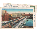
![An aerial view of Rochester on April 25, 1963. On the right is the cleared right-of-way for the final segment of the Inner Loop. [PHOTO: Local History Division, Central Library of Rochester.]](https://www.rochestersubway.com/images/photos/rochester-inner-loop-construction-01.jpg)
![The first marked bike lanes and shared use lanes will begin to appear this construction season across the city. [PHOTO: Phillip Barron]](https://www.rochestersubway.com/images/photos/bike-lane.jpg)
![Rochester is a great city for off-road cycling. The City's Bicycle Master Plan Project will seek to elevate Rochester to full 'Bicycle Friendly Community' status with the League of American Bicyclists' Bicycle Friendly Communities Program. [PHOTO: from Tobo's Flickr stream]](https://www.rochestersubway.com/images/photos/rochester_genesee_riverway_bike_trail.jpg)