


Google Maps updated their view of Rochester ![]() this week. Notice anything different? Let’s zoom in on that visual a bit…
this week. Notice anything different? Let’s zoom in on that visual a bit…
Posts Tagged ‘maps’...
See Ya Later Inner Loop. Hello, Inner Horseshoe?
Thursday, December 11th, 2014Tags: downtown Rochester, Google, Google Maps, I-490, Inner Horseshoe, Inner Loop, Inner Loop East Reconstruction Project, maps, Rochester, Rochester NY
Posted in Opinion, Rochester Images, Rochester News, Transit + Infrastructure, Urban Development | 22 Comments »
Rochester Map Typography
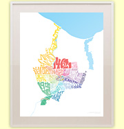
Thursday, November 20th, 2014![Rochester Map Typography [IMAGE: Rochester Public Library]](https://www.rochestersubway.com/images/photos/rochester-map-typography-1910-detail.jpg)
Preface: I am a total geek and I have stopped caring who knows it. With that out of the way, one of my favorite things in the world to do is study old maps. And my favorite part of old maps are the titles! I told you, total… geek.
I’ve always been amazed at how much attention used to go into the details of these hand-drawn works of art. These days all we do is send a satellite up into space, or someone out to drive around and snap pictures of our streets – and don’t get me wrong, that’s pretty neat for other reasons. But Google streetview ain’t got nuthin on this. Go ahead, geek out…
(UPDATE: The image shown above is now available to order.)
Tags: art, cartography, design, graphic design, hand lettering, map typography, maps, old maps, Rochester, Rochester NY, type, typography
Posted in Art + Culture, Rochester History | 6 Comments »